

A Super El Niño 2026 is no longer just a model projection sitting in a climate scientist’s spreadsheet. NASA’s Sentinel-6 Michael Freilich satellite has detected a massive wave of warm water moving across the Pacific Ocean toward South America, and the signal is strong enough that forecasters at NOAA and NASA are now treating this as one of the defining weather stories of the year. As USA Today reported on the developing pattern, climate scientist Zeke Hausfather summed up the mood succinctly: the El Niño cometh. What that means in practical terms for American summers, hurricanes, winters, and water supplies is the subject of intense forecasting activity right now, and the early signals are significant enough that everyone from farmers to coastal homeowners should be paying attention.
What NASA Actually Detected
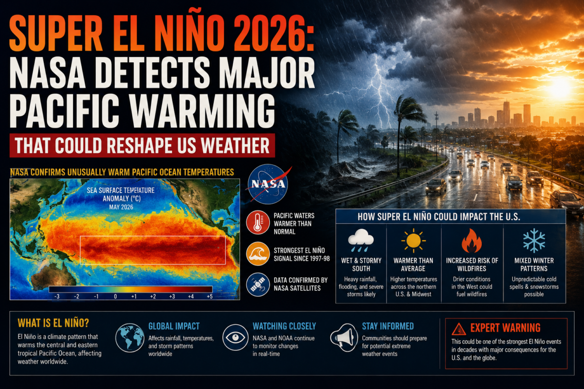
The headline data point comes directly from satellite measurements of sea level in the tropical Pacific. According to detailed reporting on the NASA findings, Sentinel-6 Michael Freilich detected a major warm Kelvin wave moving east across the Pacific, with sea levels near Peru measuring more than 5.9 inches, or 15 centimetres, above long-term averages by mid-May 2026.
What a Kelvin Wave Actually Is
A Kelvin wave, in this context, has nothing to do with the kind of wave you see breaking on a beach. It refers to an enormous, slow-moving pulse of warm water that travels along the equator beneath the ocean surface, pushed eastward by weakening trade winds. These subsurface waves can stretch for thousands of miles and carry enormous amounts of heat energy. When a Kelvin wave reaches the eastern Pacific near South America and rises to the surface, it raises sea surface temperatures across a huge stretch of ocean, which is precisely the mechanism that triggers an El Niño event.
Think of it as a massive underwater reservoir of warm water that has been building up in the western Pacific and is now draining eastward. Once that warm water surfaces near the coast of Peru and Ecuador, it changes atmospheric pressure patterns, shifts the jet stream, and reorganises weather systems across the entire globe, not just in the tropics.
Temperatures Not Seen Since 1877
The scale of the warming detected this year is what has forecasters genuinely concerned. As reporting on the developing pattern explained, the temperature of the ocean in the equatorial waters where El Niño events form was predicted to be 3 degrees Celsius above average, with experts noting that this represents a level of heat in the Pacific Ocean that has not been recorded since 1877. That comparison spans nearly 150 years of ocean temperature records, underscoring just how unusual this developing event is by historical standards.
How Fast the Forecast Odds Have Shifted
What makes this story particularly compelling from a forecasting standpoint is the speed at which probability estimates have changed. Climate scientists first detected the Kelvin wave back in March 2026 and initially estimated roughly a 22 percent chance of a Super El Niño forming. As detailed in coverage of the shifting forecast, those odds jumped to 80 percent within just a month, and European climatologists subsequently declared full confidence that a Super El Niño would develop by November 2026.
In forecasting terms, that kind of rapid jump in confidence is rare and significant. Climate models do not typically swing from roughly one-in-five odds to near-certainty within a few weeks unless the underlying physical signal, in this case the Kelvin wave and surface temperature data, is unusually strong and unusually consistent across multiple independent monitoring systems.
What NOAA’s Official Position Says
The US government’s own climate forecasting body has taken a notably more cautious tone than some of the more dramatic European analyses, which is worth noting for anyone trying to separate genuine signal from forecasting hype. According to the National Weather Service’s Climate Prediction Center, national models favor El Niño forming and persisting through the winter of 2026 to 2027, with confidence in the event’s occurrence increasing since the previous month’s outlook. However, the agency was explicit that there remains substantial uncertainty in the peak strength of the event, assigning no single strength categorisation more than a 37 percent probability.
More recently, NOAA has stated that El Niño conditions are present and expected to strengthen into winter 2026 to 2027, with a 63 percent chance of a very strong event during the November through January window. A very strong El Niño event of that magnitude would rank among the largest in the historical record dating back to 1950, though officials are careful to emphasise that this remains a probability estimate rather than a certainty.
What This Means for the 2026 Atlantic Hurricane Season
The Atlantic hurricane season officially runs from June 1 through November 30, and El Niño’s relationship with hurricane activity is one of the most well-established patterns in seasonal forecasting. Generally speaking, El Niño tends to increase wind shear over the Atlantic basin, which can disrupt the formation and intensification of hurricanes, while typically having the opposite effect in the Pacific, where El Niño years often see more active hurricane and typhoon seasons.
For coastal communities along the US Gulf Coast and Atlantic Seaboard, a strengthening El Niño could mean a somewhat less active hurricane season than feared in some earlier outlooks, though it is important to understand that El Niño affects the overall number and intensity of storms across the season rather than guaranteeing protection for any specific coastal area. A reduced overall storm count does not mean zero risk, and coastal residents should continue to follow standard hurricane preparedness guidance regardless of the seasonal outlook.
Coastal Flooding Risk Rises With a Strong El Niño
One of the more concerning and less widely discussed impacts of a strong El Niño involves coastal sea levels along the US West Coast specifically. As detailed analysis from Weather West explains, a strong El Niño event increases the likelihood of low pressure systems near the coast, which can cause additional short-duration sea level increases through storm surge and wave action. Forecasters note that ocean, bay, and estuary levels could run as much as 2 to 3 feet higher than usual during major winter storms this year, and potentially even higher if a storm coincides with the seasonal King Tides that already push water levels higher than normal.
This combination is exactly what produced significant coastal flooding during previous very strong El Niño events historically, and forecasters are not ruling out the possibility that some California and Pacific Northwest locations could break all-time historical coastal water height records this winter, given the additional contribution from long-term sea level rise and ongoing local land subsidence in some areas.
The Stratospheric Wind Pattern Adding Complexity
Beyond the ocean signal itself, atmospheric scientists are tracking a second factor that could compound El Niño’s effects on US winter weather. According to detailed analysis of the developing pattern, a major stratospheric wind shift, specifically the descending phase of what scientists call the Quasi-Biennial Oscillation, or QBO, is expected to be active for the start of winter 2026/2027. This descending west phase is expected to merge with the El Niño influence, a combination that has historically been associated with notable cold air outbreaks and significant snow events across parts of North America and Europe during winter months.
The interaction between El Niño and stratospheric wind patterns is a genuinely complex area of climate science, and forecasters are clear that more detailed analysis is still developing. What is notable is that two independent atmospheric signals, the oceanic Kelvin wave driving El Niño and the separate stratospheric wind cycle, appear to be aligning in a way that increases the odds of significant winter weather disruption across North America.
What This Means for American Farmers and the Growing Season
For US agriculture, a developing Super El Niño carries real stakes during the critical growing season. As agricultural reporting on the forecast explained, El Niño patterns typically shift moisture distribution across North America, often bringing wetter conditions to parts of the southern United States while increasing drought risk in other regions, particularly the Pacific Northwest and parts of the northern Plains.
Climate scientists are careful to caveat these projections appropriately. Stronger El Niño events do not guarantee strong impacts in any specific location; they simply make certain regional outcomes more statistically likely. Farmers and agricultural planners across the country are watching the forecast closely as they make decisions about planting schedules, irrigation planning, and crop insurance for the remainder of the 2026 growing season.
Why a Super El Niño Affects More Than Just Weather Forecasts
El Niño years carry consequences well beyond day-to-day weather. Historically, El Niño events have been associated with some of the hottest years on record globally, with the record-breaking worldwide average temperatures of 2024 occurring during a strong El Niño period. A new Super El Niño developing through late 2026 and into 2027 raises the realistic possibility that global average temperature records could be challenged again.
Super El Niño events, defined by their unusually extreme magnitude, are genuinely rare occurrences, happening roughly once per decade or less. The most recent comparable event occurred in 2015 to 2016, which produced widespread global impacts including significant coral bleaching events, severe droughts in parts of Southeast Asia and southern Africa, and major flooding across South America. If the current event verifies at the strength some models are now projecting, similar global-scale disruptions are a realistic possibility.
What Americans Should Actually Do With This Information
The honest, practical takeaway for most Americans is not panic but preparation. For coastal residents, particularly along the Pacific Coast, this is a good year to understand your property’s flood risk and ensure appropriate insurance coverage is in place well before winter storm season arrives. For anyone in hurricane-prone regions along the Gulf Coast and Atlantic Seaboard, standard hurricane season preparedness remains essential regardless of how the El Niño signal ultimately plays out, since even a quieter overall season can still produce individually destructive storms.
For anyone planning travel or outdoor events later this year, keeping an eye on seasonal forecast updates as they develop through the summer and into fall is worthwhile, particularly for trips planned to the Pacific Northwest, California, or coastal areas generally. Our guide to the best summer travel destinations across the USA for 2026 remains relevant for near-term summer planning, though the El Niño signal is primarily a story about what happens later this year and into 2027 rather than an immediate disruption to summer plans already underway.
Frequently Asked Questions (FAQs)
Q1. What exactly did NASA detect that is driving the Super El Niño 2026 forecast?
NASA’s Sentinel-6 Michael Freilich satellite detected a major warm Kelvin wave, an enormous pulse of warm subsurface water, moving east across the Pacific Ocean. By mid-May 2026, sea levels near Peru were measuring more than 5.9 inches above long-term averages, a strong early indicator that significant El Niño conditions were developing in the eastern Pacific.
Q2. How likely is a Super El Niño in 2026?
Forecasts have shifted significantly over a short period. Initial estimates in March 2026 put the odds at roughly 22 percent, rising to 80 percent within a month according to some climate scientists, while NOAA’s more conservative official outlook states a 63 percent chance of a very strong El Niño event during the November 2026 through January 2027 window. Confidence in El Niño occurring at all has increased steadily, though the exact peak strength remains uncertain.
Q3. How will El Niño affect the 2026 Atlantic hurricane season?
El Niño generally increases wind shear over the Atlantic basin, which tends to suppress hurricane formation and intensification, potentially resulting in a less active Atlantic hurricane season than in non-El Niño years. However, this does not eliminate hurricane risk entirely, and coastal residents should continue following standard preparedness guidance throughout the official June 1 to November 30 hurricane season.
Q4. Could El Niño cause coastal flooding in the United States this winter?
Yes, this is a significant concern, particularly along the US West Coast. A strong El Niño increases the frequency of coastal storms, and forecasters say ocean and bay levels could run 2 to 3 feet higher than usual during major winter storms, with even greater increases possible if storms coincide with seasonal King Tides. Some locations could potentially break historical coastal water height records this winter.
Q5. When will the Super El Niño 2026 reach its peak strength?
Most forecast models point to the event strengthening through the remainder of 2026 and peaking during the November 2026 through January 2027 window. NOAA’s Climate Prediction Center has stated that confidence in El Niño persisting through the Northern Hemisphere winter has increased, though significant uncertainty remains about exactly how strong the peak event will be.
Q6. Has there been an El Niño event as strong as this one before?
If current forecasts verify at their most extreme projections, this event could rival or exceed the historic El Niño of 1877 to 1878, based on the ocean temperature anomalies being detected. More recently, the El Niño of 2015 to 2016 is considered the most comparable modern Super El Niño event, producing widespread global impacts including major droughts, flooding, and coral bleaching events.
The Super El Niño 2026 signal detected by NASA represents one of the most significant climate stories developing in the United States and globally this year. While there remains genuine scientific uncertainty about the event’s ultimate peak strength, the underlying ocean data, the rapid Kelvin wave moving across the Pacific, and the historically unusual temperature anomalies being recorded all point toward a winter of 2026 to 2027 that could bring meaningfully different weather patterns than recent years, from hurricane activity to coastal flooding risk to agricultural growing conditions. For more science, environment, and weather coverage as this story develops throughout the year, keep reading Weblogs4u.